EARTH MAP

AND DISCOVERIES ON EARTH


The Polar Stump Claim Versus the Record

“..In the midst of the garden.” Explained..

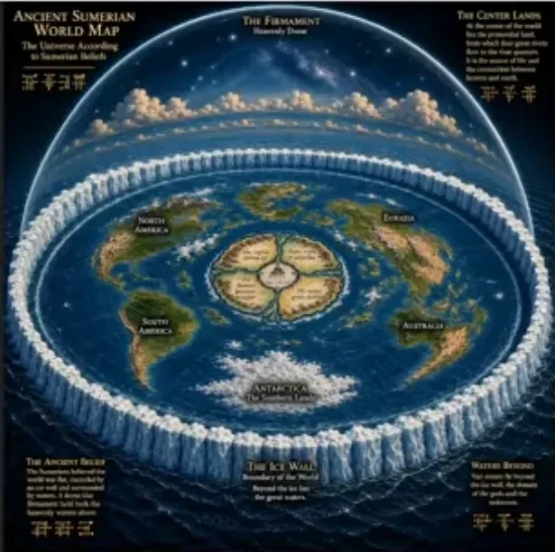
The claim that the North Pole is a leftover garden tree, that Grand Mesa is a living stump, and that old maps plus Sumerian tablets prove a closed disk world is easy to sell on video. It is harder to defend once you check the sources.


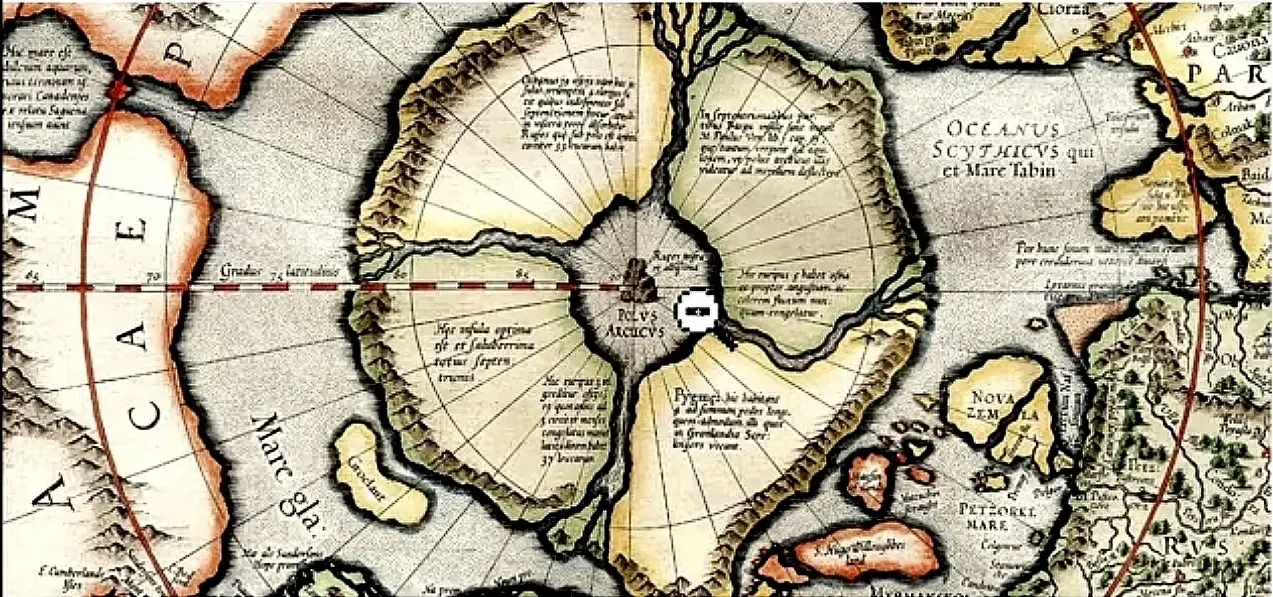
Gerard Mercator’s polar map from the 1590s shows four land masses, four inward waters, a whirlpool, and a black magnetic rock labeled Rupes Nigra.

That drawing did not come from a survey of the pole. It came from a lost book called Inventio Fortunata, known only through later summaries. Mercator copied the story in a 1577 letter to John Dee: a bare rock about 33 French miles around, waters rushing in as if through a funnel, and four channels. People used that story because they needed a reason for compass needles to point north. Later ships and later maps found sea ice, not a black rock and not a drain. A printed guess is not a photograph of Eden.

The David Rumsey Map Collection holds high resolution scans of old atlases. Some later maps also put a compass rose or a sun like mark near the pole. That is map decoration and inherited theory, not proof of four garden rivers still running into a tree core. Zooming in on ink does not turn a 16th century rumor into ground truth. If you want the actual plate, use the collection, not a screenshot from a video.

Hebrew in Genesis 2:9 does place the tree of life “in the midst of the garden.” The word group is betokh hagan. Midst means the middle of that garden. It does not move the garden to 90 degrees north. Genesis also names Tigris and Euphrates. Those rivers sit in Mesopotamia. The Bible text does not say the Arctic Circle is the fence of Eden. Reading “middle” and then dropping the rest of the chapter is not careful reading. It is selection.


Sumerian flood and paradise texts do overlap with Genesis on a few points: a flood, a boat, long lived early kings, a blessed place with water.

That is shared ancient Near East storytelling. Those tablets do not give a measured pillar at the geographic North Pole, an ice wall, or a firmament map that matches modern flat earth diagrams. “They confirm Genesis, therefore this polar stump is real” is two jumps, not one fact.

Grand Mesa is in western Colorado, not Arizona. It is one of the largest flat top mountains on Earth, about 500 square miles, rising thousands of feet above the valleys. The cap is old basalt from lava that filled a low area and later sat high after the land around it wore down. That is inversion, not a cut trunk. There are hundreds of lakes and ponds on top. Water comes from snow, rain, and groundwater moving through rock. Springs discharging from below are normal geology. They are not leftover tree pipes. The rock is not wood. There is no measured root system tens of miles deep feeding a living stump.

Mount Kirikabu in Oita Prefecture, Japan, is a real hill whose name means cut stump. Local legend says a huge camphor was felled and the stump became the mountain. The old Bungo Fudoki already ties the place name Kusu to a great camphor. That is folklore attached to a mesa like shape. A name and a story do not turn basalt and soil into a petrified trunk. The same rule applies to tepuis in Venezuela. People name rocks after trees. Rocks stay rocks.

Trees have height limits. Gravity, water lift, and wood strength cap real trees near a little over 100 meters. A mesa tens of miles across is not a scaled up cedar. If you cut a tree that size, you would still have wood anatomy, bark, rings, and roots that match wood. Grand Mesa does not. Calling every flat top a stump is pattern matching.


The Black Rock company name is not proof that finance was copied from Rupes Nigra. The old map used “black rock” as a magnet story. A modern firm using two common English words is not a confession.

The Vatican pine cone statue and the bishop mitre have their own long records in Rome and in church dress. Sumerian apkallu figures hold a pine cone and a bucket in ritual scenes. Similar shapes across centuries do not prove the same cult still runs the world from the pole. Similarity is cheap. Causation is expensive.

The idea that “we still live in the garden but outside the center” is a sermon, not a location fix. The Arctic Ocean is mapped, sailed, flown, and measured. There is no public, verified 33 mile black core with four inhabited islands and a whirlpool swallowing the seas. If that feature existed at the size claimed, it would not be a secret kept by silence. It would be a navigation hazard and a survey target.

Old maps, flood legends, and odd landforms are worth study. They show how people explained magnets, water, and mountains before modern instruments.


The polar stump claim rests on three things that are real and one thing that is not.

Real: Mercator’s 1590s Arctic plate shows four lands, inward waters, a whirlpool, and Rupes Nigra.

Real: Genesis 2:9 puts the tree of life in the midst of the garden.

Real: Grand Mesa and Mount Kirikabu look like flat tops and carry stump talk in local naming.

Not proven: that any of this is a leftover Garden tree at 90 north.

Mercator did not survey the pole. He used Inventio Fortunata through later summaries, then restated it to John Dee in 1577: a bare magnetic rock about 33 French miles around and water running in like a funnel. That solved a live problem of the day, why needles point north, before anyone had a field model. Ships after that found ice, not a drain. The David Rumsey scans are useful here. They show how later plates kept the inherited polar mark. Ink and a compass rose are map habit. They are not a field check of four garden rivers.

On the text side, betokh hagan means in the middle of that garden. The same chapter names Tigris and Euphrates, which sit in Mesopotamia. Sumerian flood and paradise material overlaps Genesis on a flood, a boat, long early reigns, and a watered blessed place. That overlap is old Near East literature doing what old Near East literature does. It does not hand you a surveyed pillar at the geographic pole or an ice rim diagram.


Grand Mesa is in western Colorado. Area is about 500 square miles. The high cap is basalt from old flows that later sat high after the valleys dropped.

Hundreds of lakes sit on top. Water is snow, rain, and groundwater in rock. Springs from below are normal on that kind of pile. The rock is not wood and there is no published root system tens of miles down. Mount Kirikabu in Oita, Japan, is named cut stump and the camphor legend is old enough to show up in the Bungo Fudoki tie to Kusu. Tepuis pick up the same kind of names. Naming a landform after a tree is common.

Other links people like are cheap if you treat likeness as proof. BlackRock shares two ordinary words with the old black rock on the map. Vatican pine cone sculpture and Sumerian figures with a cone and bucket are real objects with their own records. Eyes, flowers, and poles repeat in design because people copy centers. None of that locates a 33 mile core in the Arctic Ocean. That ocean has been sailed, flown, and charted. A feature that size would be a survey object, not a rumor.


What Scripture Indicates

Genesis and 1 Enoch share a small set of pictures: a garden with a special tree, water that splits or flows from a holy place, a flood that answers violence before Noah, and a sky treated as a built structure with edges, storehouses, and openings. They do not locate that garden at the geographic North Pole. They also do not call Grand Mesa a trunk.

Genesis 2:8 to 2:14 plants a garden eastward in Eden. The tree of life and the tree of the knowledge of good and evil stand in the midst of the garden. One river goes out of Eden to water the garden, then splits into four heads: Pishon, Gihon, Hiddekel (Tigris), and Euphrates. Two of those names still sit on the map of Mesopotamia. Genesis 3:24 puts cherubim and a flaming sword on the east of the garden after the expulsion. That is the Bible’s own geography talk. Midst means middle of that garden. It does not rename the Arctic. learn.ligonier.org

Genesis 1:6 to 1:8 has God make a firmament that splits waters above from waters below. Genesis 7:11 then opens both systems in the flood: fountains of the great deep burst, and the windows of heaven open. Genesis 6:1 to 6:4 is brief on the sons of God, daughters of men, and mighty men of old. Genesis does not expand that into a full Watcher story. It moves straight to the flood. en.wikipedia.org


1 Enoch fills the gap Genesis leaves short. In the Book of the Watchers, two hundred Watchers descend, take wives, teach forbidden crafts, and father giants. God sends Uriel to Noah, then binds the Watchers and uses the flood as cleanup. That’s why people pair Enoch with Genesis 6. The flood is the same event class. The cast list is longer. tianmu.org

Enoch also has trees that readers connect to Eden. In 1 Enoch 24 to 25 he sees a high mountain like a throne and a fragrant tree no mortal may touch until judgment. Many readers call that the tree of life. In 1 Enoch 32 he reaches the Garden of Righteousness and the tree of wisdom. Raphael says that is the tree Adam and Eve ate, after which they knew they were naked and were driven out. So Enoch keeps two garden sites in view: a future tree at God’s mountain, and an older garden of wisdom tied to the first pair. 2 Enoch 8 puts the tree of life in the midst of paradise in the third heaven, with its root “in the garden at the earth’s end.” That last line is the closest Enochic hook people use for an edge of the world garden. It is still not a survey of 90 north. sacred-texts.com

On the shape of the world, 1 Enoch 18 is the chapter flat earth readers quote most. Enoch sees storehouses of the winds, the cornerstone of the earth, four winds that bear the earth and the firmament, and winds that stand as pillars of heaven. He sees the end of the earth with the firmament of heaven above it.

He also sees a waste place with no firmament above and no founded earth below, used as a prison for stars that missed their times. 1 Enoch 33 to 36 then walks the ends of the earth and the gates of heaven in the four directions. It matches the older Near East habit of talking about a constructed sky. It does not give Mercator’s Rupes Nigra, four polar islands, or a 33 mile black core. answersingenesis.org

A side connection that keeps coming up in later Enoch related texts is trees as a code for Watchers and giants. Fragments tied to the Book of Giants treat trees in a dream as the Watchers, and the giants as what came from them. Damascus Document language compares the giants to tall cedars. That is why stump and fallen tree folklore gets pulled into this file. It is metaphor in those texts, not a field ID of a mesa. marquette.edu

What lines up: garden, midst, special tree, four way water in Genesis, flood after mixed beings, firmament and windows, Enoch’s longer Watcher story, Enoch’s two tree visions, and Enoch’s ends of the earth tour.

What does not line up: a named North Pole pillar in Genesis, a measured polar stump in Enoch, or a command to read every flat top mountain as a cut trunk.


Worth keeping: old maps as a record of magnet theory, flood stories as a record of shared memory, mesas as a record of lava and wear.

Worth dropping: disk Earth from a lookalike photo, living stumps from a place name, finance as a copy of a polar hole. Check the plate in Rumsey. Check the 1577 letter. Check the river names in Genesis 2. Keep what still stands after that.


Sources;

https://en.wikipedia.org/wiki/Inventio_Fortunata
https://en.wikipedia.org/wiki/Rupes_Nigra

https://www.davidrumsey.com 
https://archive.org/details/dr_text-page-to-polus-arcticus-ac-terrarum-circumjacentium-descriptio-10805002
https://en.wikipedia.org/wiki/Grand_Mesa
https://en.wikipedia.org/wiki/Grand_Mesa_National_Forest
https://coloradogeologicalsurvey.org/publications/geologic-map-mesa-lakes-quadrangle-mesa-delta-colorado/
https://ja.wikipedia.org/wiki/%E4%BC%90%E6%A0%AA%E5%B1%B1
https://oita-tourism.com/en/attractions/detail_1092.html
https://biblehub.com/text/genesis/2-9.htm
https://en.wikipedia.org/wiki/Eridu_Genesis
https://science.feedback.org/review/mesas-buttes-and-similar-landforms-are-created-by-deposition-and-erosion-they-are-not-the-remains-of-ancient-trees/

Share

#thebrutaltruthnewspodcast #substack #CheckTheMap #NotATreeStump #SourceNotScreenshot


FAIR USE COPYRIGHT NOTICE:

substack.com/@originalbrutaltruth SEPTEMBER 2026 The Copyright Laws of the United States recognizes a “fair use” of copyrighted content. Thank you all for subscribing. If you enjoy and feel the information shared here is important, please share it!

The videos and YouTube channel in general may contain certain copyrighted works that were not specifically authorized to be used by the copyright holder(s), but which we believe in good faith are protected by federal law and the fair use doctrine for purposes such as criticism, comment, news reporting, teaching, parody, or research, is not an infringement of copyright. All video is for educational purposes only. We believe this constitutes a fair use of any such copyrighted material as provided for in section 107 of the US Copyright Law


How the M7.6 Caribbean Quake Triggered Tectonic Activity at Yellowstone Updates


On February 9, 2025, a powerful magnitude 7.6 earthquake struck approximately 209 km south-southwest of George Town in the Cayman Islands, sending seismic ripples through the Caribbean region. The quake originated along the Swan Islands Transform Fault, a major left-lateral strike-slip fault that forms part of the tectonic boundary between the Caribbean Plate and the North American Plate. This fault system extends across the western Caribbean Sea, running along the northern coast of Honduras and stretching toward Jamaica and the Cayman Islands.


The Swan Islands Transform Fault is a complex geological feature where two tectonic plates slide past each other in a horizontal motion, rather than the subduction or uplift processes commonly associated with earthquake-induced tsunamis or volcanic activity. Transform faults are notorious for generating powerful earthquakes, as the accumulated stress from plate movements is periodically released in sudden, violent shifts. This event, which occurred at a depth of roughly 10 kilometers, resulted in strong ground shaking across the region, prompting tsunami warnings for parts of the Caribbean coastline, though no significant waves were ultimately recorded.


The earthquake was felt as far away as Jamaica, Cuba, and parts of Central America, causing temporary power outages, structural damage, and landslides in some coastal areas. Seismic activity along the Swan Islands Fault is not uncommon, as the Caribbean region sits on a network of active tectonic boundaries, including the Puerto Rico Trench, the Hispaniola Trench, and the Enriquillo-Plantain Garden Fault Zone, which runs through Haiti and the Dominican Republic. This interconnected system of faults means that large seismic events in one region can influence stress levels in other areas, potentially leading to further seismic activity.


While the M7.6 earthquake was a significant event, the direct geological link between the Caribbean fault system and distant locations like Yellowstone remains weak. The Yellowstone Caldera, a super volcano in the western United States, sits atop a massive hotspot, which is not driven by tectonic activity in the same way as Caribbean fault movements. While seismic waves from large earthquakes can propagate globally, their effects on distant volcanic and geothermal systems are typically limited to minor hydrothermal changes, such as shifts in geyser activity or increased ground movement.


In recent years, studies have explored how large earthquakes can trigger distant seismic responses, particularly in regions with existing geological instability.

However, for an earthquake in the Caribbean to directly trigger activity at Yellowstone, there would need to be a deeper tectonic connection, such as a shared fault system or direct stress transfer, neither of which exists between these two regions. Yellowstone’s activity is primarily governed by mantle plumes and localized crustal stresses, making it largely independent from external seismic influences.


That said, scientists continue to monitor both regions closely, as seismic activity in one part of the world can sometimes lead to unexpected geological shifts elsewhere. The M7.6 earthquake serves as a reminder of the intricate and dynamic nature of the Earth's crust, where seemingly isolated events are part of a much larger, interconnected system of geological forces.


The Swan Islands Transform Fault facilitates the lateral movement between these two tectonic plates, with the Caribbean Plate moving eastward relative to the westward-moving North American Plate. Such transform boundaries are characterized by horizontal motion, where plates slide past one another. While significant earthquakes along these faults can induce seismic waves that propagate over vast distances, their direct impact on regions as distant as Yellowstone is minimal.


Yellowstone National Park is situated atop the Yellowstone Caldera, a super volcano primarily influenced by the dynamics of the North American Plate and underlying mantle plumes. The tectonic activities in the Caribbean, including the recent M7.6 earthquake, are not directly connected to the geological processes governing Yellowstone. Historically, even substantial seismic events in the western United States have not triggered volcanic eruptions at Yellowstone. For instance, the U.S. Geological Survey notes that while large earthquakes can affect hydrothermal features in Yellowstone, they do not cause volcanic eruptions.


In summary, while the M7.6 Caribbean earthquake is a significant tectonic event within its region, it has not triggered tectonic activity at Yellowstone. The geological settings and tectonic drivers of these two areas are distinct and operate independently.


USGS

Wikipedia, the free encyclopedia

How the M7.6 Caribbean Quake Triggered Tectonic Activity at Yellowstone


Copyright Disclaimer under Section 107 of the Copyright Act of 1976: Allowance is made for “fair use” for purposes such as criticism, comment, news reporting, teaching, scholarship, education, and research.


Beyond the Ice Wall of Antarctica


Antarctica stands as the southernmost and least-populated continent on Earth, predominantly situated below the Antarctic Circle and encompassed by the Southern Ocean, also known as the Antarctic Ocean. Home to the geographic South Pole, it holds the distinction of being the coldest, driest, and windiest of all continents, with the highest average elevation. Primarily a polar desert, it experiences minimal annual precipitation, exceeding 200 mm (8 in) along the coast but considerably less inland. 

The indigenous animal species include mites, nematodes, penguins, seals, and tardigrades. Vegetation, where present, primarily manifests as lichen or moss.


Enormous Pre-Flood Mega-Structure Discovered in Siberia


The Gornaya Shoria megaliths, known for their immense stone blocks resembling granite, were notable for their flat surfaces and right angles. Even more astonishing was their estimated weight, exceeding 3,000 tons. This makes the Gornaya Shoria megaliths the largest megalithic stones ever found in human history.


Africa Is SPLITTING IN HALF And Something Extraordinary Is

About To Happen


In elementary science, we have gathered a lot of knowledge about the continents and their history, how the continents as we know them only sometimes exist the way they are today and the role that continental drift played in this. However, what if we told you another historical geological event might be upon our planet? A new Ocean is being formed in Africa as we speak. Where and how is this happening? Watch this video till the end to get the full details!


Recently, Kenya's Great Rift Valley has become an area of interest to individuals worldwide, specifically scientists. The never-ending exploratory activities in this region are triggered by the fact that it is the region where Africa, the second largest continent in the world, is gradually dividing into two as a result of natural forces.

An event of this extent hasn't been recorded for a couple of million years, and the last of its kind marked the division of South America and Africa into two different continents. On a lighter note, the site resulting from this split, Kenya's Great Rift Valley, is a choice site for tourists traveling to East Africa to witness the phenomenon firsthand.


The division of the African continent into two became very obvious in 2005. This division originated from the emergence of a rift in the Ethiopian desert, which is 35 miles long at the moment, as stated by geophysical research charts. According to Scientists, this division in the African continent started long before 2005 and will eventually lead to the continent splitting into two parts with an ocean in between.


NEVER BEFORE SEEN PHOTOS OF BEYOND THE ICE WALL IN ANTARCTICA


Looks like a strange mix of South American and Greco-Roman architecture. If this is the real deal, maybe Alexander wept for no more worlds to conquer because he really had found the foundation of the firmament?


! ~🚨AIR🛦WAR🛦ALERT🚨~ ! EXPERIMENTAL💫HYPERSONIC⚡ATTACK⚡AIRCRAFT ELECTRONICALLY

DISABLED OVER ANTARCTICA~!


Google Earth Pro 2023 HI RES MAXAR QUANTUM 4K SATELLITE IMAGERY!!
Experimental Aircraft shoot down Location.... 73°47'9.12"S 4°32'33.83"W


The 6 US Cities Most at Risk of Danger in a Nuclear Attack


When it comes to nightmare scenarios for the United States, a nuclear attack from a foreign power has to rank among the worst possible choices. While the likelihood of such a strike is low, that does not stop experts from trying to prepare for any possibility. A new story by Business Insider lists the following six cities as the most likely to be at risk in the event of a future nuclear attack on the United States: 1) Chicago, Illinois 2) Houston, Texas 3) Los Angeles, California 4) New York, New York 5) San Francisco, CA 6) Washington, DC


Here Is Where You Can Take

Shelter During Nuclear War In US


According to the survivalist website Survivalfreedom.com, the upper Midwest, Maine, West Texas, and several small pockets, typically in places with few populations, are where you can take shelter during a nuclear war in the US.


The survivalist website linked to a Federal Emergency Management Agency (FEMA) map that shows the locations of Russian intercontinental ballistic missiles (ICBMs) that are most likely to hit those locations.


A more detailed map of US nuclear targets is provided here.


MELTING ICE IN ANTARCTICA NOW REVEALS
EVIDENCE OF MASSIVE ANCIENT CONTINENTAL ENGINEERING PROJECT(!)


Comments -


-Love these Antarctica videos, and I'm in total agreement about the evidence supportive of something living under the ice up there with advanced technology that modern society doesn't possess. A civilization that has lived there and travels around the globe from there.


-I have to admit, absolutely fascinating. Your research on this so interesting. I have no doubt that the biggest hidden secret is down there and its going to be too hard for them to hide anymore. Great job brother. From Miami ,FL.💪


-When the truth of Antarctica is released, it will change everything we have learned about the history and the nature of the earth completely. We then will ascend to the place we were intended to be as a culture and a race. We are just about to get there now. What a wonderful time to be alive!